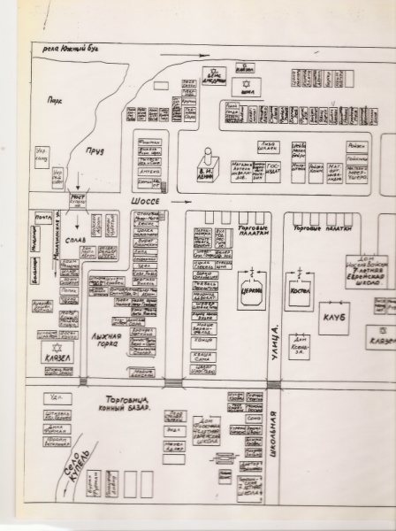
Street map of the Kupel the Shtetl was created by Chaim Beider, Abram Udler and Cilya Derman in 1970-80. When they came to Kupel after the war, there was no shtetl anymore. All Jewish homes, shops, barns were destroyed, disassembled and used in Ukrainian households in order to prevent survivors return to Kupel. So kupelians, who survided the war fighting Germans in the Russian Army, or working on some plants in Siberia, they wanted to remember their birthplace, which they still loved, and they created a Map. Street by street, house by house, name by name.
My grandmother, Bertha Glaser, told me, that houses in the shtetl were so close to each other, you can hear what people talking about in a neighboring house. Land was an issue for the Jews, even as around the shtetl there was a lot of land layed in waste. After the February of 1917 Revolution, when Pale of Settlement was eliminated and Jews got equal rights as any other citizens, Jews got the right to land too.
Подомовая карта местечка Купел была создана Хаимом Бейдером, Абрамом Удлером и Цилей Дерман. Когда после войны они вернулись в Купель, местечка они не нашли. После убийства евреев местные украинцы разрушили все еврейские дома, магазины, школу, даже сараи, а имущество и материалы разграбили, растащили по себе. Этим они хотели предотвратить возвращение тех евреев, кто уцелел благодаря службе в армии, или в эвакуации на заводах Сибири. И купельские евреи решили восстановить местечко, их родину, хотя бы на бумаге, на Карте. И они это сделали: дом за домом, семья за семьей, улица за улицей.